
|
Colorado and the Arkansas River Basin continue to see improvements in drought conditions with almost 16% of the state no longer experiencing drought, according to the latest U.S. Drought Monitor report. The report shows most of the basin as abnormally dry or drought-free with moderate drought in some areas. 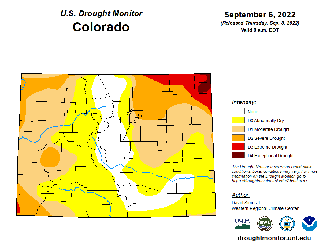 Precipitation
The CoCoRaHS (Community Collaborative Rain, Hail and Snow) Network reports the following precipitation amounts for the past week in the Arkansas Basin:
Reservoir Storage The past week saw water storage in Pueblo Reservoir decrease by almost 3,000 acre-feet to 179,688 acre-feet, putting the reservoir at 55.6% full. Water storage in Turquoise Lake decreased to 87,593.8 acre-feet or 67.7% full. The water level in Twin Lakes increased to 118,229 acre-feet, bringing the reservoir to 83.9% full. The U.S. Army Corps of Engineers reports 14,361 acre-feet of water currently stored in John Martin Reservoir. River Flows Arkansas River flows continue to diminish, with the gauge near Leadville reporting 29.6 cfs, while the gauge below Granite currently registers 197 cfs. The flow at the Wellsville gauge is 386 cfs, and the flow at Cañon City is currently 318 cfs. The river flow below Pueblo Reservoir is 104 cfs, and the gauge near Avondale reports 214 cfs. The gauge near Rocky Ford reports 96.7 cfs, flows are 51.7 cfs below John Martin Reservoir, and the gauge at Lamar currently reports 52.5 cfs. Calling Water Rights Calling water rights in the basin jumped to 19 this week with six calls on the mainstem: the Lamar Canal (1875 priority), Bessemer Ditch (1882), the Fort Lyon Canal (1884 priority), the Buffalo Canal (1885), the X-Y Irrigating Ditch (1889) and the Arkansas River Compact call at the Kansas state line. The most senior calling water right in the basin is currently the Talcott and Cotton Ditch with an 1864 priority date on Fountain Creek at its confluence with the Arkansas River. Next most senior are the Titsworth Ditch on Fourmile Creek, the Hayden Supply Ditch on Greenhorn Creek and the Hoehne Ditch on the Purgatoire River, all of which have 1865 priority dates. With 1866 priority dates, the Baxter Pioneer Ditch is calling for water on the Huerfano River, and the Gonzales Ditch has a call on the Apishapa River. The Coleman Ditch (1867) has a call for water on Hardscrabble Creek, and the Gomez Ditch (1868) has a call on the Cucharas River. Additional calling water rights include the MuelBach Pleasant Valley diversion (1873) on Hayden Creek, the Hill Ditch (1873) on Howard Creek, the Supply Ditch (1874) on Cottonwood Creeek, the Seth Brown Ditch (1876) on Stout Creek and the Dotson Ditch No. 1 (1881) on the St. Charles River.. Colorado and the Arkansas River Basin saw slight improvements in drought conditions this week with more than 13% of the state no longer experiencing any level of drought, according to today's U.S. Drought Monitor report. The report shows no drought in most of the basin's headwaters areas, abnormally dry conditions in most of lower basin with a few patches of moderate. 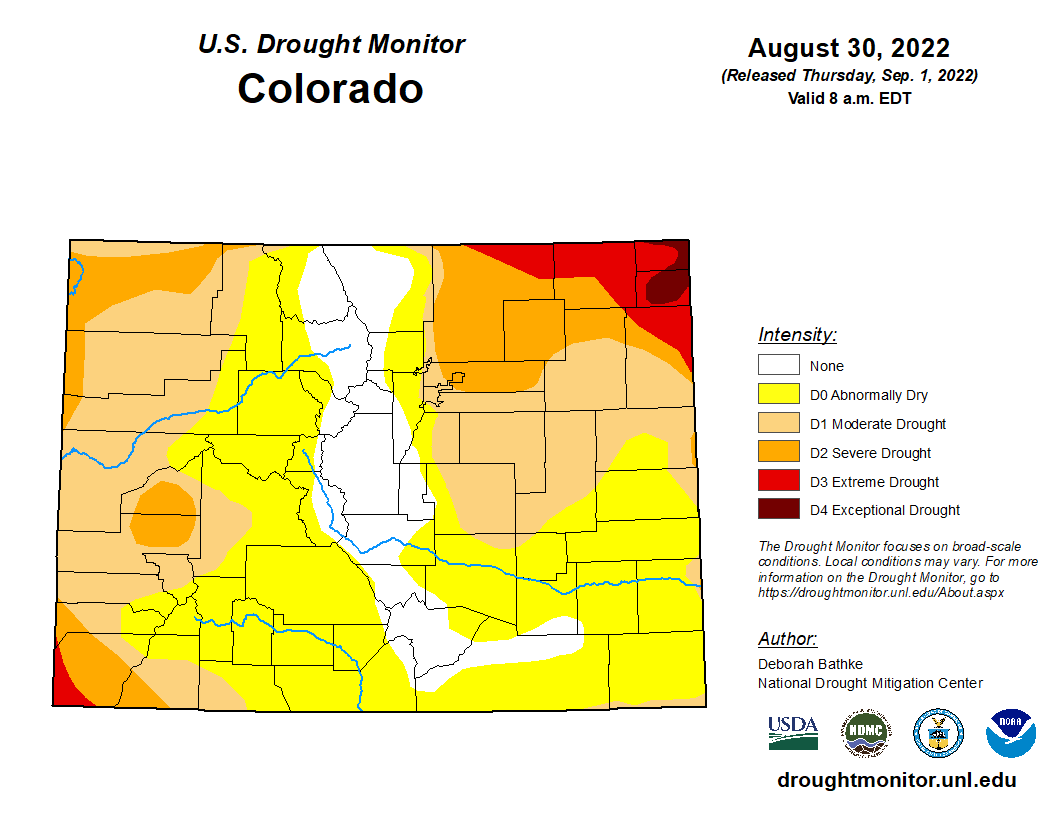 Precipitation
The CoCoRaHS (Community Collaborative Rain, Hail and Snow) Network reports the following precipitation amounts for the past week:
Reservoir Storage The past week saw water storage in Pueblo Reservoir drop from 184,178 acre-feet to 182,230 acre-feet, putting the reservoir at 56.4% full . Water storage in Turquoise Lake decreased to 93,454.8 acre-feet or 72.2% full. The water level in Twin Lakes increased to 112,341 acre-feet, bringing the reservoir to 79.7% of full. The U.S. Army Corps of Engineers reports 15,003 acre-feet of water currently stored in John Martin Reservoir, which has a capacity of 348,599 acre-feet. River Flows Arkansas River flows near Leadville dropped to 40 cfs this week, while the gauge below Granite currently registers 218 cfs. The flow at the Wellsville gauge is 420 cfs while the flow at Cañon City is currently 348 cfs. The river flow below Pueblo Reservoir is at 258 cfs, the same as a week ago, and the gauge near Avondale reports 396 cfs. The gauge near Rocky Ford reports 173 cfs after after dropping as low as 66.4 cfs the night of Aug. 25. Flows are 71.9 cfs below John Martin Reservoir, and the gauge at Lamar currently reports 53.5 cfs. River Calls The Arkansas Basin currently has 14 calling water rights, including the same four mainstem rights as last week: the Catlin Canal (1884 priority), the Lamar Canal (1886), the X-Y Irrigating Ditch (1889) and the Arkansas River Compact call at the Kansas state line. The most senior calling water right is the Hayden Supply Ditch (1864) on Greenhorn Creek. Next in seniority are the Hamlet Ditch on the Huerfano River, the Bannister Sump Well at the confluence of Fountain Creek and the Arkansas River, and the Gonzales Ditch on the Apishapa River. All three diversions have 1866 priority dates. Additional calling water rights include the Coleman Ditch (1867) on Hardscrabble Creek, the Pulaski Ditch (1868) on the Purgatoire River, the Kittredge Ditch No. 2 (1870) on West Fourmile Creek, and the Hill Ditch (1873) on Howard Creek. Rounding out the active calls for this week are the Watson Ditch No. 2 (1874) on Fourmile Creek and the Marmaduke Ditch (1878) on Stout Creek. The current weather pattern continues to bring precipitation to Colorado, lifting more than 12% of the state out of drought conditions and lessening drought severity in the rest of the state, according to today's U.S. Drought Monitor report. The report categorizes most of the Arkansas Basin as abnormally dry with with only a thin sliver of severe drought along the Oklahoma state line. 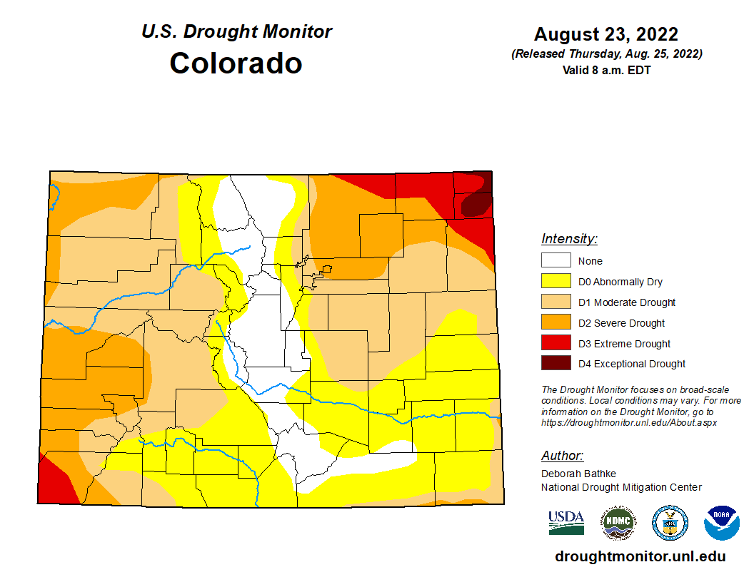 Precipitation
The CoCoRaHS (Community Collaborative Rain, Hail and Snow) Network reports the following precipitation amounts for the past week:
Reservoir Storage Water storage in Pueblo Reservoir remains little changed this week – 184,178 acre-feet, or 57% full – according to data from the U.S. Bureau of Reclamation. Water storage in Turquoise Lake decreased to 97,904.2 acre-feet or 75.7% full. The water level in Twin Lakes increased to 106,773 acre-feet, also 75.7% full. With Voluntary Flow Management Program (VFMP) targets for recreational boating done for 2022, the Bureau of Reclamation has reduced releases from Twin Lakes to its 15 cfs minimum flow. Data for John Martin Reservoir is not available at this time. River Flows Arkansas River flows near Leadville declined to 52.7 cfs this week, while the gauge below Granite currently registers 274 cfs. The flow at the Wellsville gauge is 440 cfs with an almost identical flow of 444 cfs at Cañon City. The river flow below Pueblo Reservoir has dropped to 258 cfs, and the gauge near Avondale reports 408 cfs after peaking at 860 cfs this past week. The gauge near Rocky Ford reports 73.6 cfs after peaking at 217 cfs Monday. Flows are 82.4 cfs below John Martin Reservoir but held steady at a high of 256 cfs Saturday through Monday. The gauge at Lamar currently reports 27.6 cfs after spiking to 94.5 cfs just before midnight Monday. River Calls The Arkansas Basin currently has 15 calling water rights, including the usual number, four, on the mainstem: the Catlin Canal (1884 priority), the Lamar Canal (1886), the X-Y Irrigating Ditch (1889) and the Arkansas River Compact call at the Kansas state line. The most senior calling water right is the Tom Wanless Ditch (1864) at the confluence of Fountain Creek and the Arkansas River. Next in seniority is the Gonzales Ditch (1866) on the Apishapa River, followed by the Coleman Ditch (1867) on Hardscrabble Creek and the Pulaski Ditch (1868) on the Purgatoire River. Additional calling water rights include the Adams Ditch (1869) on Fourmile Creek, Hill Ditch (1873) on Howard Creek, the Cottonwood and Maxwell Ditch (1874) on Cottonwood Creek, the Marmaduke Ditch (1878) on Stout Creek, the Dotson Ditch No. 1 (1881) on the St. Charles River, the Hoosier Ditch (1882) on the North Fork of the South Arkansas River and the JM Murray Ditch (1887) on Muddy Creek. According to today's U.S. Drought Monitor report, most of the basin remains abnormally dry with severe/extreme drought persisting in portions of southern Baca County. 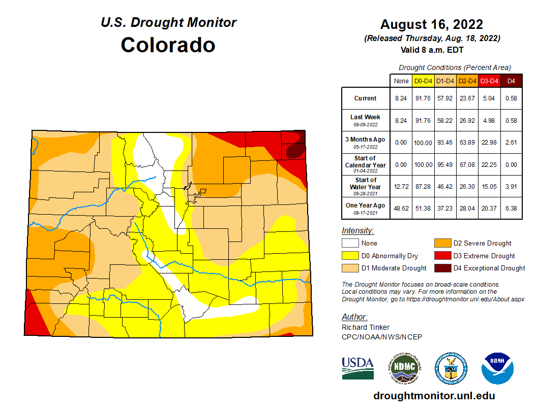 Precipitation
The CoCoRaHS (Community Collaborative Rain, Hail and Snow) Network reports the following precipitation amounts for the past week:
Reservoir Storage U.S. Bureau of Reclamation data shows an incremental increase in Pueblo Reservoir water storage to 185,701 acre-feet, or 57.5% full. Water storage in Turquoise Lake decreased to 102,284 acre-feet or 79.0% full. Twin Lakes storage saw a slight increase to 102,616 acre-feet, or 72.8% full, as the Bureau continues to release Fry-Ark Project water in support of the Voluntary Flow Management Program (VFMP). Water stored in John Martin Reservoir decreased to 15,090 acre-feet, according to the U.S. Army Corps of Engineers. River Flows Arkansas River flows near Leadville increased to 77.6 cfs this week, while the gauge below below Granite currently registers 374 cfs. Flows at the Wellsville gauge are at 573 cfs. Flows at Cañon City have decreased to 607 cfs and are 476 cfs below Pueblo Reservoir. The gauge near Avondale reports 815 cfs, and the gauge near Rocky Ford reports 124 cfs. Flows are 33.9 cfs below John Martin Reservoir and 50.4 cfs at Lamar. River Calls Calling water rights in the Arkansas Basin remain at 14 this week. In addition to the Arkansas River Compact call at the Kansas state line, calls on the mainstem are from the Catlin Canal (1884 priority), the Amity Canal (1887) and the X-Y Irrigating Ditch (1889). The most senior calling water rights are the O'Brien Ditch (1865) on Fourmile Creek, the Gonzales Ditch (1866) on the Apishapa River, the Coleman Ditch (1867) on Hardscrabble Creek and the Pulaski Ditch (1868) on the Purgatoire River. Additional calling water rights include the Hill Ditch (1873) on Howard Creek, the Cottonwood and Maxwell Ditch (1874) on Cottonwood Creek, the Seth Brown Ditch (1876) on Stout Creek, the Dotson Ditch No. 1 (1881) on the St. Charles River, the Hoosier Ditch (1882) on the North Fork of the South Arkansas River and the Bott Ditch (1889) on Muddy Creek. Monsoon rains have lifted a swath of the Arkansas River Basin out of drought conditions – from southern Chaffee County to Otero County, including parts of Fremont, Custer and Huerfano counties – according to today's U.S. Drought Monitor report. The report categorizes most of the basin as abnormally dry with extreme drought persisting only in a small portion of southern Baca County. 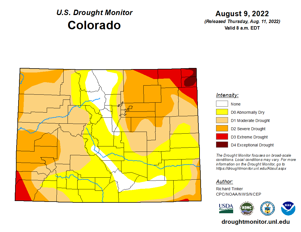 Precipitation
The CoCoRaHS (Community Collaborative Rain, Hail and Snow) Network reports the following precipitation amounts for the past week:
Reservoir Storage U.S. Bureau of Reclamation data shows an incremental increase in Pueblo Reservoir water storage to 185,011 acre-feet, or 57.3% full. Water storage in Turquoise Lake decreased to 106,502 acre-feet or 82.3% full. Twin Lakes storage decreased to 102,047 acre-feet, or 72.4% full, as the Bureau continues to release Fry-Ark Project water in support of the Voluntary Flow Management Program (VFMP). Recent rainfall increased water stored in John Martin Reservoir to 15,394 acre-feet, according to the U.S. Army Corps of Engineers. River Flows Arkansas River flows near Leadville declined to 41.8 cfs this week, while the gauge below below Granite currently registers 623 cfs. Flows at the Wellsville gauge are at 730 cfs, in line with the VFMP target of 700 cfs. Flows at Cañon City have increased to 718 cfs and are 218 cfs below Pueblo Reservoir. The gauge near Avondale reports 385 cfs, and the gauge near Rocky Ford reports 258 cfs after peaking at 565 cfs Wednesday. Flows are 252 cfs below John Martin Reservoir and 22.6 cfs at Lamar. River Calls Calling water rights in the Arkansas Basin have dropped from 16 to 14 this week. In addition to the Arkansas River Compact call at the Kansas state line, calls on the mainstem are from the Catlin Canal (1884 priority), the Amity Canal (1887) and the X-Y Irrigating Ditch (1889). The most senior calling water rights are the O'Brien Ditch (1865) on Fourmile Creek, the Gonzales Ditch (1866) on the Apishapa River, the Coleman Ditch (1867) on Hardscrabble Creek and the Pulaski Ditch (1868) on the Purgatoire River. Additional calling water rights include the Hill Ditch (1873) on Howard Creek, the Cottonwood and Maxwell Ditch (1874) on Cottonwood Creek, the Seth Brown Ditch (1876) on Stout Creek, the Dotson Ditch No. 1 (1881) on the St. Charles River, the Hoosier Ditch (1882) on the North Fork of the South Arkansas River and the Bott Ditch (1889) on Muddy Creek. Rainfall continues to ease drought conditions across the Arkansas Basin, with extreme drought lingering in only a thin sliver of southern Baca County, according to the latest U.S. Drought Monitor report. The report shows severe drought continuing along the southern and eastern edges of the basin with about half the basin experiencing moderate drought. Most of the Front Range and Upper Basin is now categorized as abnormally dry. 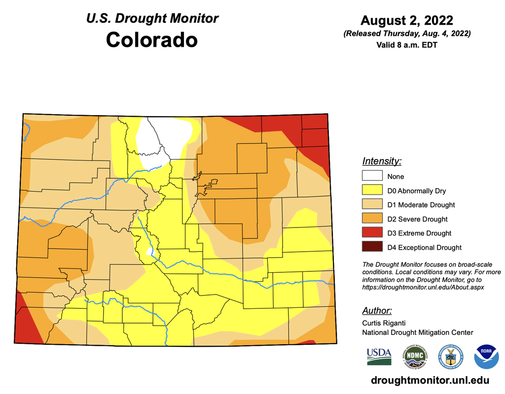 Precipitation
CoCoRaHS, the Community Collaborative Rain, Hail and Snow Network, reports the following precipitation amounts for the past week:
U.S. Bureau of Reclamation reservoir data shows Pueblo Reservoir water storage increased slightly to 184,575 acre-feet, 57.1% full. Water storage in Turquoise Lake water storage decreased to 110,026 acre-feet or 85.3% full. Twin Lakes storage decreased to 103, 103 acre-feet, or 73.1% full, as the Bureau has begun releasing Fry-Ark Project water in support of the Voluntary Flow Management Program (VFMP). According to the U.S. Army Corps of Engineers, water stored in John Martin Reservoir increased to 15,372 acre-feet. River Flows Arkansas River flows near Leadville increased to 61.8 cfs this week, while flows below Granite decreased to 574 cfs. Flows at the Wellsville gauge are at 736 cfs. Flows at Cañon City have increased to 691 cfs and are 383 at Pueblo. Lower Ark Basin gauges are reporting 486 cfs near Avondale, 158 cfs near Rocky Ford, 118 cfs below John Martin Reservoir and 80 cfs at Lamar. River Calls The basin again has 16 calling water rights. In addition to the Arkansas River Compact call, calling rights on the mainstem are the Catlin Canal (1884 priority), the Lamar Canal (1886) and the X-Y Irrigating Ditch (1889). The most senior calling water rights remain the Titsworth Ditch (1863) on Fourmile Creek, the Model Ditch (1865) on the Purgatoire River and the Hayden Supply Ditch (1866) on Greenhorn Creek. Additional calling water rights include the Baxter Pioneer Ditch (1866) on the Huerfano River, the Gonzales Ditch (1866) on the Apishapa River, the Coleman Ditch (1867) on Hardscrabble Creek and the Cottonwood and Maxwell Ditch (1874) on Cottonwood Creek. Other calls are for the Marmaduke Ditch (1878) on Stout Creek, the Dotson Ditch No. 1 (1881) on the St. Charles River, the Hoosier Ditch (1882) on the North Fork of the South Arkansas River, the Missouri Park Ditch (1882) on the South Ark River, the Lake Mirriam Ditch (1884) on the Cucharas River and the Welton Ditch (1889) on the Huerfano River. |
