
|
High winds and dry conditions continued across much of the Arkansas River Basin this past week, prompting Red Flag warnings and burn bans. Nonetheless, wildfires broke out in Bent, Otero and Custer counties as well as at Fort Carson. Moderate to severe drought conditions dominate most of the basin with extreme to exceptional drought persisting in the southeast corner of the state. Colorado Snowpack Map for April 16 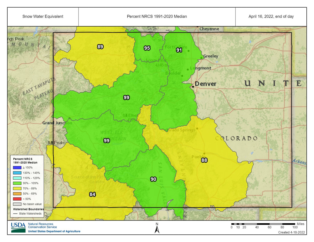 Snowpack
National Resources Conservation Service data show that the past week’s dry, windy conditions in the Arkansas Basin dropped snowpack from 97% to 88% of median (based on snow-water equivalent). Despite the basin-wide trend, snowpack increased at some NRCS SNOTEL sites, including Porphyry Creek, which currently reports 115% of median, up from 98%. Saint Elmo snowpack is back up to 111% after dropping to 100% the previous week. Fremont Pass rebounded to 93%, up 8 percentage points. Snowpack at Apishapa and Hayden Pass dropped to 91% and 82%, respectively. Reservoir Storage Current data from the U.S. Bureau of Reclamation shows Pueblo Reservoir at 69.7% of capacity with 225,051 acre-feet of water in storage. Other Reclamation reservoirs, like Twin Lakes and Turquoise Lake, are not currently reporting these numbers. The Army Corps of Engineers report for April 15 shows 45,188 acre-feet of water currently stored in John Martin Reservoir, which has a capacity of 348,599 acre-feet. River Flows The Colorado Division of Water Resources reports Arkansas River flows are currently 114 cfs at Granite and 205 cfs at the Wellsville gauge near the Fremont-Chaffee County line, below the Voluntary Flow Management target of 250 cfs. In Cañon City, Arkansas River flows are 232 cfs. Below Pueblo Dam, flows are 108 cfs, 305 cfs near Avondale and 183 cfs near Rocky Ford. Below John Martin Reservoir flows have crept up to 0.46 cfs. At Lamar flows are 6.82 cfs, the same as a week ago. River Calls Active calls for water in the Arkansas Basin are at 11, with six calls on the mainstem, unchanged from a week ago. Calling water rights continue to include the Lamar Canal with an 1875 priority date, the Fort Lyon Canal with an 1884 priority date and the Buffalo Canal with an 1885 priority date. Tributary calls include the Model Ditch with an 1862 priority date on the Purgatoire River, the Titsworth Ditch with an 1865 priority date on Fourmile Creek, the Gonzales Ditch with an 1866 priority date on the Apishapa River, the May Ditch with an 1869 priority date on the Huerfano River, and the Hardscrabble Ditch with an 1871 priority date on Hardscrabble Creek. Comments are closed.
|
Archives
July 2024
Categories |
 RSS Feed
