
|
High winds continued to plague Colorado and the Arkansas River Basin this week, contributing to several wildfires. The U.S. Drought Monitor shows little change across Colorado with moderate to severe drought conditions across most of the basin, but the drought map has not been updated to reflect Sunday's snowstorm, which improved snowpack. The NOAA three-month temperature and precipitation outlook was recently updated, projecting above-normal temperatures and below-normal precipitation for all of Colorado through July. Colorado Snowpack Map for April 24 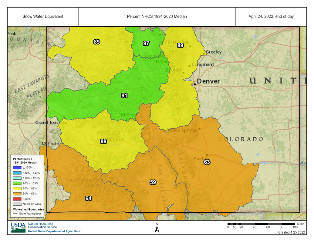 Snowpack
According to the National Resources Conservation Service (NRCS), basin snowpack dropped to 63% of median, measured as snow-water equivalent, as of April 24. Ark Basin SNOTEL data from April 25 show Porphyry Creek at 89% of median, Saint Elmo at 81%, Fremont Pass at 88% and Hayden Pass at 32%. The Apishapa SNOTEL station reads 150% of median, but that reading has been flagged as likely not valid. Reservoir Storage Current reservoir data from the U.S. Bureau of Reclamation shows Pueblo Reservoir is 68.8 % full with 222,249 acre-feet of water in storage. Twin Lakes Reservoir is 68% full with 95,873.7 acre-feet in storage. Turquoise Lake currently stores 47,501.5 acre-feet of water and is 36.7% full. U.S. Army Corps of Engineers data shows 44,444 acre-feet of water currently stored in John Martin Reservoir, well below its capacity of 348,599 acre-feet. River Flows Arkansas River flows have increased since last week, with gauges reading 318 cfs below Granite, 346 cfs at Wellsville and 352 cfs at Cañon City. Below Pueblo Dam, flows are 324 cfs, 745 cfs near Avondale and 162 cfs near Rocky Ford. Below John Martin Reservoir flows have ramped up to 75.4 cfs. At Lamar flows are currently 47.5 cfs. Voluntary Flow Management Program Flows at Wellsville are on target for the Voluntary Flow Management Program for April 1 to May 15. River Calls Calling water rights in the Arkansas Basin increased from 11 to 18 active calls this week. Seven calls are on the mainstem, including the 1875 Lamar Canal water right, the 1884 Fort Lyon Canal right and Las Animas Consolidated water right. The most senior calling water right is the Chilili Ditch with an 1862 priority date on the Huerfano River. Other tributary calls include Bray Ditch on North Cottonwood Creek with an 1867 priority date, the Bannister Sump Well on Fountain Creek with an 1866 priority date, the Titsworth Ditch on Fourmile Creek with an 1865 priority date, and the Gonzales Ditch on the Apishapa River with an 1866 right. Comments are closed.
|
Archives
July 2024
Categories |
 RSS Feed
