
|
Colorado's February precipitation failed to maintain Arkansas River Basin snowpack compared to the past 20 years. The U.S. Drought Monitor shows severe drought persisting in most areas in the basin with extreme drought in the southern edge of the lower Ark Basin in Colorado as well as the two western corners of Colorado (i.e., 9% of the state). The NOAA three-month temperature outlook projects higher than normal temperatures across all of Colorado through May. The three-month outlook also predicts lower than normal precipitation for the entire state. 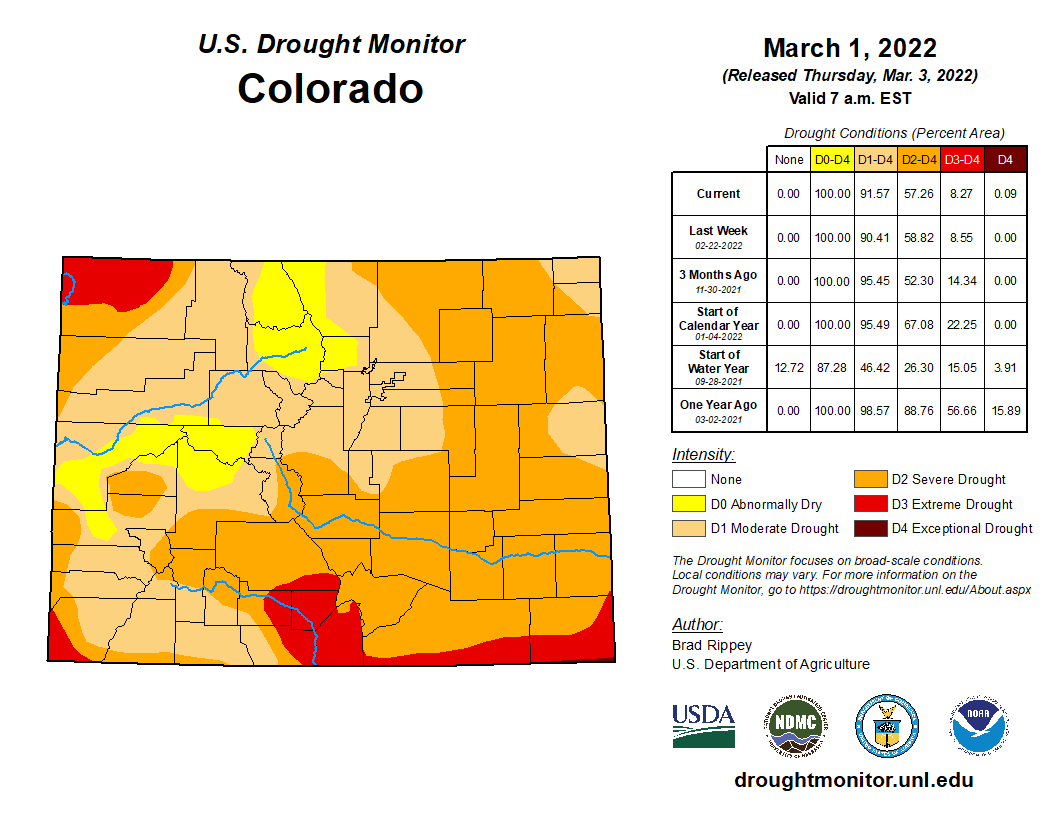 Snowpack
The latest National Resources Conservation Service (NRCS) Snowpack Telemetry (SNOTEL) report shows basin-wide snowpack at 76% of median for snow-water equivalent (SWE) and precipitation at 83% of median. The highest snowpack readings continue to be recorded at Porphyry Creek (119%) and Saint Elmo (115%). Snowpack at Fremont Pass has dropped from 102% of median a month ago to a current reading of 90%. The Apishapa SNOTEL station reports 75% while the Hayden Pass station improved from 40% a month ago to 69% at present. Reservoir Storage Statewide reservoir storage was reported at 78% of average and 43% of total capacity during the February Governor's Water Availability Task Force meeting. This link accesses the latest NRCS reservoir report, which is unfortunately producing suspect and incomplete data for February. The issue should be resolved soon. River Flows As of March 5, Arkansas River flows were 252 cfs at Granite, 393 cfs at the Wellsville gauge near Salida and 361 cfs at Cañon City. Below Pueblo Dam, flows were 64.9 cfs, increasing to 276 cfs near Avondale before dropping to 155 cfs near Rocky Ford. The flow was 1.64 cfs below John Martin Reservoir and 10.6 cfs at Lamar. Boustead Tunnel discharge rates were not available as of this writing. River Calls The Arkansas River Basin had eight active calls as of March 5. The Fort Lyon Storage Canal remains the calling water right on the Arkansas mainstem with a March 1, 1910, priority date. The Holitas Reservoir has a call on the Cucharas River with a March 20, 1901, priority date. The Upper Huerfano No. 2 is the calling structure on the Huerfano River with a priority date of March 15, 1869. The Model Ditch (March 20, 1862) continues its call on the Purgatoire River, as does the Tenassee Ditch (April 30, 1880) on the South Arkansas River. Additional calls are in place on Fourmile Creek and Greenhorn Creek. The Winter Water Storage Program ends March 14, which will likely impact calling water rights. Comments are closed.
|
Archives
July 2024
Categories |
 RSS Feed
