
|
Rainfall continues to ease drought conditions across the Arkansas Basin, with extreme drought lingering in only a thin sliver of southern Baca County, according to the latest U.S. Drought Monitor report. The report shows severe drought continuing along the southern and eastern edges of the basin with about half the basin experiencing moderate drought. Most of the Front Range and Upper Basin is now categorized as abnormally dry. 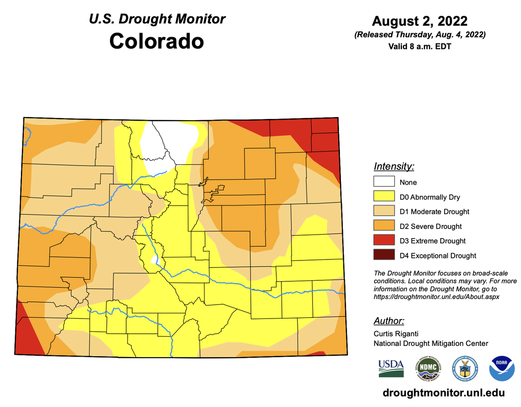 Precipitation
CoCoRaHS, the Community Collaborative Rain, Hail and Snow Network, reports the following precipitation amounts for the past week:
U.S. Bureau of Reclamation reservoir data shows Pueblo Reservoir water storage increased slightly to 184,575 acre-feet, 57.1% full. Water storage in Turquoise Lake water storage decreased to 110,026 acre-feet or 85.3% full. Twin Lakes storage decreased to 103, 103 acre-feet, or 73.1% full, as the Bureau has begun releasing Fry-Ark Project water in support of the Voluntary Flow Management Program (VFMP). According to the U.S. Army Corps of Engineers, water stored in John Martin Reservoir increased to 15,372 acre-feet. River Flows Arkansas River flows near Leadville increased to 61.8 cfs this week, while flows below Granite decreased to 574 cfs. Flows at the Wellsville gauge are at 736 cfs. Flows at Cañon City have increased to 691 cfs and are 383 at Pueblo. Lower Ark Basin gauges are reporting 486 cfs near Avondale, 158 cfs near Rocky Ford, 118 cfs below John Martin Reservoir and 80 cfs at Lamar. River Calls The basin again has 16 calling water rights. In addition to the Arkansas River Compact call, calling rights on the mainstem are the Catlin Canal (1884 priority), the Lamar Canal (1886) and the X-Y Irrigating Ditch (1889). The most senior calling water rights remain the Titsworth Ditch (1863) on Fourmile Creek, the Model Ditch (1865) on the Purgatoire River and the Hayden Supply Ditch (1866) on Greenhorn Creek. Additional calling water rights include the Baxter Pioneer Ditch (1866) on the Huerfano River, the Gonzales Ditch (1866) on the Apishapa River, the Coleman Ditch (1867) on Hardscrabble Creek and the Cottonwood and Maxwell Ditch (1874) on Cottonwood Creek. Other calls are for the Marmaduke Ditch (1878) on Stout Creek, the Dotson Ditch No. 1 (1881) on the St. Charles River, the Hoosier Ditch (1882) on the North Fork of the South Arkansas River, the Missouri Park Ditch (1882) on the South Ark River, the Lake Mirriam Ditch (1884) on the Cucharas River and the Welton Ditch (1889) on the Huerfano River. Rainfall continues to ease drought conditions across the Arkansas Basin, with extreme drought lingering in only a thin sliver of southern Baca County, according to the latest U.S. Drought Monitor report. The report shows severe drought continuing along the southern and eastern edges of the basin with about half the basin experiencing moderate drought. Most of the Front Range and Upper Basin is now categorized as abnormally dry. 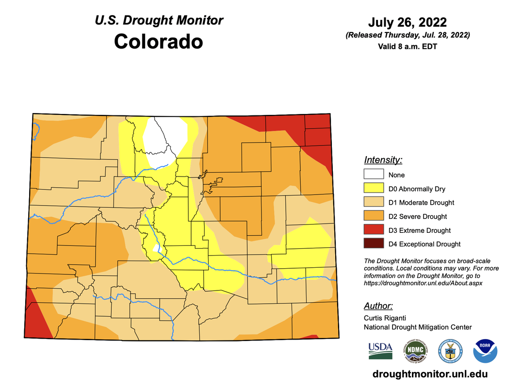 Precipitation
CoCoRaHS, the Community Collaborative Rain, Hail and Snow Network, reports the following precipitation amounts for the past week:
U.S. Bureau of Reclamation reservoir data shows Pueblo Reservoir water storage decreased to 184,430 acre-feet, 57.1% full. Water storage in Turquoise Lake water storage increased to 184,430 acre-feet or 85.5% full. Twin Lakes storage decreased to 104,251 acre-feet, or 73.9% full, as the Bureau has begun releasing Fry-Ark Project water in support of the Voluntary Flow Management Program (VFMP). According to the U.S. Army Corps of Engineers, water stored in John Martin Reservoir dropped to 14,788 acre-feet. River Flows Arkansas River flows near Leadville dropped to 54.9 cfs this week, while flows below Granite increased to 585. Flows at the Wellsville gauge are at 724 cfs. Flows at Cañon City have increased to 664 cfs and are 440 at Pueblo. Lower Ark Basin gauges are reporting 747 cfs near Avondale, 475 cfs near Rocky Ford, 107 cfs below John Martin Reservoir and 95.9 cfs at Lamar. River Calls The basin again has 16 calling water rights. In addition to the Arkansas River Compact call, calling rights on the mainstem are the Catlin Canal (1884 priority), the Lamar Canal (1886) and the X-Y Irrigating Ditch (1889). The most senior calling water rights remain the Titsworth Ditch (1863) on Fourmile Creek, the Model Ditch (1865) on the Purgatoire River and the Hayden Supply Ditch (1866) on Greenhorn Creek. Additional calling water rights include the Baxter Pioneer Ditch (1866) on the Huerfano River, the Gonzales Ditch (1866) on the Apishapa River, the Coleman Ditch (1867) on Hardscrabble Creek and the Cottonwood and Maxwell Ditch (1874) on Cottonwood Creek. Other calls are for the Marmaduke Ditch (1878) on Stout Creek, the Dotson Ditch No. 1 (1881) on the St. Charles River, the Hoosier Ditch (1882) on the North Fork of the South Arkansas River, the Missouri Park Ditch (1882) on the South Ark River, the Lake Mirriam Ditch (1884) on the Cucharas River and the Welton Ditch (1889) on the Huerfano River. Rainfall continues to ease drought conditions across the Arkansas Basin, with extreme drought lingering in only a thin sliver of southern Baca County, according to the latest U.S. Drought Monitor report. The report shows severe drought continuing along the southern and eastern edges of the basin with about half the basin experiencing moderate drought. Most of the Front Range and Upper Basin is now categorized as abnormally dry. 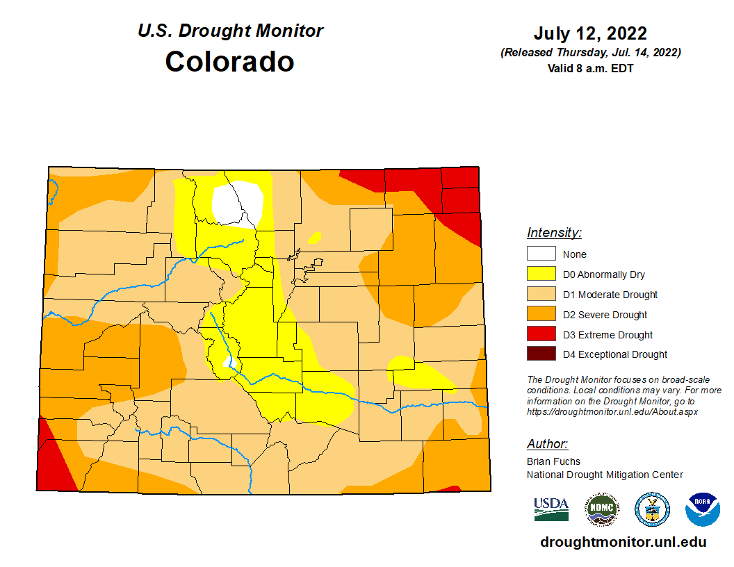 Precipitation
CoCoRaHS, the Community Collaborative Rain, Hail and Snow Network, reports the following precipitation amounts for the past week:
U.S. Bureau of Reclamation reservoir data shows Pueblo Reservoir water storage decreased to 187,781 acre-feet, 58.1% full. Water storage in Turquoise Lake remains virtually unchanged since last week at 110,592 acre-feet or 85.5% full. Twin Lakes storage decreased to 112,820 acre-feet, or 80.0% full, as the Bureau has begun releasing Fry-Ark Project water in support of the Voluntary Flow Management Program (VFMP). According to the U.S. Army Corps of Engineers, water stored in John Martin Reservoir dropped to 18,004 acre-feet. River Flows Arkansas River flows near Leadville dropped to 65.5 cfs this week, while flows below Granite decreased to 517 cfs before climbing to 596 cfs as the Bureau increased Twin Lakes releases in support of the VFMP. Flows at the Wellsville gauge are at the VFMP target of 700 cfs. Flows at Cañon City have decreased to 553 cfs and are 630 cfs below Pueblo Dam. Lower Ark Basin gauges are reporting 831 cfs near Avondale, 230 cfs near Rocky Ford, 120 cfs below John Martin Reservoir and 118 cfs at Lamar. River Calls The basin again has 16 calling water rights. In addition to the Arkansas River Compact call, calling rights on the mainstem are the Catlin Canal (1884 priority), the Lamar Canal (1886) and the X-Y Irrigating Ditch (1889). The most senior calling water rights remain the Titsworth Ditch (1863) on Fourmile Creek, the Model Ditch (1865) on the Purgatoire River and the Hayden Supply Ditch (1866) on Greenhorn Creek. Additional calling water rights include the Baxter Pioneer Ditch (1866) on the Huerfano River, the Gonzales Ditch (1866) on the Apishapa River, the Coleman Ditch (1867) on Hardscrabble Creek and the Cottonwood and Maxwell Ditch (1874) on Cottonwood Creek. Other calls are for the Marmaduke Ditch (1878) on Stout Creek, the Dotson Ditch No. 1 (1881) on the St. Charles River, the Hoosier Ditch (1882) on the North Fork of the South Arkansas River, the Missouri Park Ditch (1882) on the South Ark River, the Lake Mirriam Ditch (1884) on the Cucharas River and the Welton Ditch (1889) on the Huerfano River. The summer monsoon weather pattern continued during the past week, bringing slight improvement to drought conditions across the Arkansas Basin. According to the latest U.S. Drought Monitor report, 1.52% of Colorado is no longer experiencing drought, including a small area in southern Chaffee County. 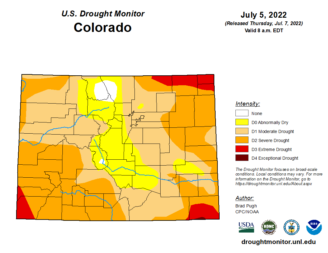 Precipitation
The Community Collaborative Rain, Hail and Snow Network reported the following precipitation amounts for the past week:
U.S. Bureau of Reclamation reservoir data shows Pueblo Reservoir water storage decreased slightly to 191,096 acre-feet, 59.2% full. The volume of water in Turquoise Lake increased since last week to 110,392 acre-feet or 85.3% full. Twin Lakes storage decreased to 115,217 acre-feet, 81.7% full as the Bureau increased outflows to 340 cfs before cutting back to 290 cfs today. According to the U.S. Army Corps of Engineers, water stored in John Martin Reservoir dropped below 20,000 acre-feet to 19,435. River Flows Arkansas River flows near Leadville dropped to 103 cfs this week, while flows below Granite increased to 572 cfs due to increased releases from Twin Lakes. Flows at the Wellsville gauge peaked at 1,030 cfs July 8 but dropped to 826 cfs this morning, above the Voluntary Flow Management Program target. The Cañon City gauge currently reports 724 cfs. Flows below Pueblo Dam exceeded 1,200 cfs last week but are currently 692 cfs. Flows are 1,090 cfs near Avondale, 584 cfs near Rocky Ford, 584 cfs below John Martin Reservoir and 90.4 cfs at Lamar. River Calls The Arkansas Basin has 16 active calls, the same number as last week. The four calls on the mainstem are the Amity Canal (1887 priority), the Lamar Canal (1887), the X-Y Irrigating Ditch (1889) and the 1949 Arkansas River Compact call at the Kansas state line. The Titsworth Ditch remains the remains the most senior calling water right in the basin with an 1863 priority date on Fourmile Creek. The Model Ditch on the Purgatoire River (1865), the Hayden Supply Ditch on Greenhorn Creek (1866), and the Jose Marie Vigil Ditch 2 on Trujillo Creek (1867) are the next most senior calling rights, followed by the Coleman Ditch on Hardscrabble Creek (1867). Other calls are for the Upper Huerfano No. 1 on the Huerfano River (1868), the RB Willis Ditch on Wahatoya Creek (1870), the Calf Pasture Ditch on the Cucharas River (1871), the Marmaduke Ditch on Stout Creek (1878), the Dotson Ditch No. 1 on the St. Charles River (1881) and the Hoosier Ditch on the North Fork of the South Arkansas River (1882). Monsoonal weather continued during the past week, ending drought conditions in part of southern Chaffee County and continuing to lessen drought severity across the Arkansas Basin, with only a sliver of exceptional drought continuing in the southeast corner of the Colorado. Data from the latest U.S. Drought Monitor report is a week old, so the next Drought Monitor map should show even more improvement when it is released Thursday. 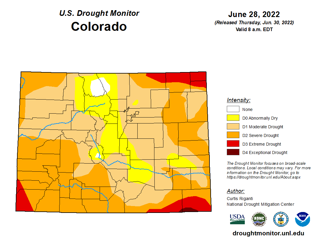 Precipitation
The Community Collaborative Rain, Hail and Snow Network reported the following precipitation amounts for the past week:
Reservoir data from the U.S. Bureau of Reclamation shows the water level in Pueblo Reservoir dropped slightly to 60.6% full with 195,633 acre-feet of water in storage. The Bureau reported increased inflows to Turquoise and Twin Lakes reservoirs as a result of monsoon precipitation. As a result, Turquoise Lake water storage increased to 109,471 acre-feet or 84.6% full. Twin Lakes storage decreased slightly to 117,564 acre-feet, 83.4% full as the Bureau increased outflows to 237 cfs. The U.S. Army Corps of Engineers indicates a slight decrease in the amount of water stored in John Martin Reservoir to 20,640 acre-feet. River Flows July 1 signaled the beginning of the Voluntary Flow Management Program's (VFMP's) flow targets to support an extended whitewater boating season on the upper Arkansas River. Through the VFMP, owners of Fryingpan-Arkansas Project water agree to release up to 10,000 acre-feet of water from upper-basin Fry-Ark reservoirs (Turquoise and Twin Lakes) to benefit whitewater recreation from July 1 until Aug. 15. The Southeastern Colorado Water Conservancy District, which manages Fry-Ark Project water, has reported 44,136 acre-feet of Fry-Ark water imports this year, ensuring adequate supplies to meet VFMP target flows. Arkansas River flows increased to 125 cfs near Leadville thanks to monsoonal precipitation, but flows below Granite dropped nearly 100 cfs during the past week to 530 cfs. Flows at the Wellsville gauge dropped to 856 cfs but remained above the VFMP target of 700 cfs. The Cañon City gauge currently reports 704 cfs. Flows below Pueblo Dam are currently 842 cfs and are 1,170 cfs near Avondale. Near Rocky Ford, flows are 443 cfs, and below John Martin Reservoir, 519 cfs. The gauge at Lamar reports 98.7 cfs. River Calls Currently, the Arkansas Basin has 16 active calls. Calls on the mainstem include the Oxford Canal (1887 priority), the X-Y Irrigating Ditch (1889), the Lamar Canal (1890) and the 1949 Arkansas River Compact at the Kansas state line. The Titsworth Ditch, with its 1863 priority date on Fourmile Creek, remains the most senior calling water right in the basin, followed by the Model Ditch on the Purgatoire River (1865). The Hayden Supply Ditch (1866) continues to call for water on Greenhorn Creek, as does the Gonzales Ditch (1866) on the Apishapa River and the Welton Ditch (1889) on the Huerfano River. Other calls are from the Harrington Ditch (1868) on Hardscrabble Creek, Upper Huerfano No. 1 on the Huerfano River, the RB Willis Ditch (1870) on Wahatoya Creek, and the Cameron Ditch (1882) on the North Fork of the South Arkansas River above Poncha Springs. Colorado saw the return of monsoon weather patterns this past week, bringing welcome precipitation to the Arkansas Basin. Drought conditions have moderated, but the only part of the state no longer experiencing some level of drought as of June 21 was in Jackson and Lamar counties in northern Colorado. The June 30 update to the Drought Monitor map, will continue to trend toward less severe drought conditions. 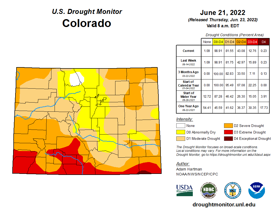 Precipitation
The Community Collaborative Rain, Hail and Snow Network reported the following precipitation amounts for the past week:
Current reservoir data from the U.S. Bureau of Reclamation shows the water level little changed in Pueblo Reservoir at 61.4% full with 198,335 acre-feet of water in storage. Turquoise Lake water storage increased to 107,416 acre-feet or 83% full. Twin Lakes Reservoir water storage increased slightly to 118,467 acre-feet, 84% full, in spite of increases in outflow as reported by the Bureau of Reclamation. U.S. Army Corps of Engineers data show 21,500 acre-feet of water currently stored in John Martin Reservoir. River Flows Arkansas River flows dropped to 131 cfs near Leadville and 624 cfs below Granite. Flows at the Wellsville gauge declined during the week but increased today to match last week's flow of 1,140 cfs, including 5 cfs of Fry-Ark Project water. The Cañon City gauge currently reports 1,000 cfs. Flows below Pueblo Dam have increased to 888 cfs and to 1,260 cfs near Avondale. Near Rocky Ford, flows are 347 cfs and below John Martin Reservoir, 413 cfs. The gauge at Lamar reports 110 cfs. River Calls Currently, the Arkansas Basin has 13 active calls and two authorized diversions – the Welton and Jose Maria ditches on the Huerfano River. The three calls on the mainstem remain unchanged from a week ago – the Amity Canal (1887 priority), the X-Y Irrigating Ditch (1889) and the 1949 Arkansas River Compact at the Kansas state line. The most senior calling right is the Titsworth Ditch with an 1863 priority date on Fourmile Creek, followed by the Model Ditch on the Purgatoire River (1865 priority). The Hayden Supply Ditch (1866) continues to call for water on Greenhorn Creek, as does the Gonzales Ditch (1866) on the Apishapa River, and the Garcia Ditch No. 2 (1867) and Welton Ditch (1889) on the Huerfano River. New calling water rights are the Fernandez Ditch (1868) on Turkey Creek and the Dotson Ditch No. 1 (1881) on the Saint Charles River. |
