
|
The weekend brought welcome precipitation to parts of the Arkansas Basin, but the U.S. Drought Monitor continues to show varying levels of drought basin-wide. NOAA's three-month temperature outlook, released June 16, shows a 50-60% likelihood of above-normal temperatures in most of Colorado through September. The three-month outlook shows a likelihood of normal to below normal precipitation in Colorado. 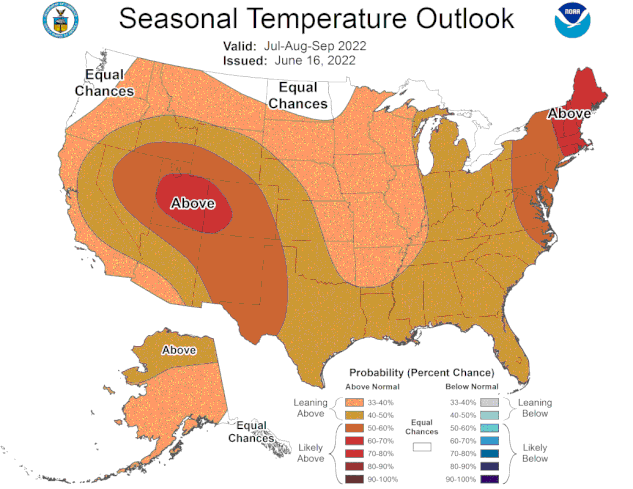 Precipitation
The Community Collaborative Rain, Hail and Snow Network reported the following precipitation totals for the weekend in the basin:
Current reservoir data from the U.S. Bureau of Reclamation shows Pueblo Reservoir is 62% full as of June 19 with 200,150 acre-feet of water in storage. Turquoise Lake water storage increased to 104,314 acre-feet or 80.6% of full. Twin Lakes Reservoir water storage increased to 117,705 acre-feet, 83.5% of full. Reclamation reports an increase in inflows from precipitation bump, prompting an increase of 50 cfs in water releases to 129 cfs, almost all of which is native Ark Basin water. U.S. Army Corps of Engineers data show 23,181 acre-feet of water currently stored in John Martin Reservoir, which has a capacity of 348,599 acre-feet. River Flows Arkansas River flows are 177 cfs near Leadville, 796 cfs below Granite and 1,140 cfs at the Wellsville gauge, which includes 5 cfs of Fry-Ark Project water. The Cañon City gauge currently reports 993 cfs. Flows are currently 800 cfs below Pueblo Dam and 904 cfs near Avondale. Flows are 424 cfs near Rocky Ford and 478 cfs below John Martin Reservoir. The gauge at Lamar reports 80 cfs. River Calls Currently, the Arkansas Basin has 14 active calls. The three calls on the mainstem are the 1887 Amity Canal water right, the 1889 X-Y Irrigating Ditch right and the 1949 Arkansas River Compact at the Kansas state line. The most senior calling right is the Lewelling-McCormick with an 1864 priority date on the Purgatoire River, followed by the H.R. Steele Sump (1865 priority) on Fountain Creek at the confluence with the Ark River. The Hayden Supply Ditch (1866 priority) is calling on Greenhorn Creek, and the Gonzales Ditch (1866 priority) continues to call for Apishapa River water. The Garcia Ditch No. 2 (1867) and the Welton Ditch (1889) have calls on the Huerfano River. The Calf Pasture Ditch (1871) has a call on the Cucharas River. Remaining calls are on Fourmile, Hardscrabble, Wahatoya and Stout creeks with priority dates ranging from 1867 to 1880. While May precipitation lessened drought severity in Colorado, the entire Arkansas River Basin continues to experience drought conditions – ranging from Abnormally Dry in parts of Chaffee, Fremont, Teller, El Paso and Pueblo counties to Exceptional Drought in part of Baca County – according to the latest latest U.S. Drought Monitor report. 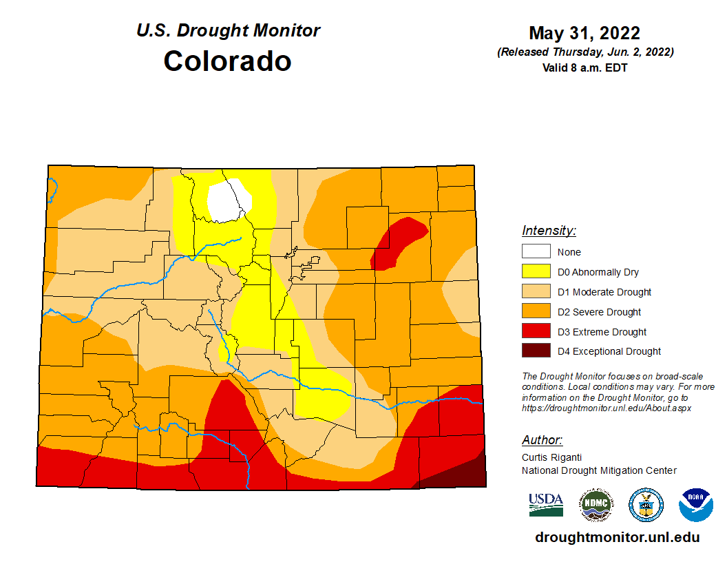 Snowpack
The National Resources Conservation Service (NRCS) reports Arkansas Basin snowpack, measured as snow-water equivalent, just above median at 101% as of May 5. Reservoir Storage Current reservoir data from the U.S. Bureau of Reclamation show Pueblo Reservoir is 63.4% full as of June 6 with 204,906 acre-feet of water in storage. Twin Lakes Reservoir is 77.9% full at 109,793 acre-feet. Turquoise Lake is currently 63.5% full and stores 82108.8 acre-feet of water, and U.S. Army Corps of Engineers data show 27,042 acre-feet of water currently stored in John Martin Reservoir. River Flows Arkansas River flows appear to have reached their peak for 2022 with current flows of 164 cfs near Leadville, 1,030 cfs below Granite, 1,380 cfs at Wellsville and 1,500 cfs at Cañon City. Below Pueblo Dam and near Avondale, flows are 1,350 cfs and 1,640 cfs, respectively. Flows are 584 cfs near Rocky Ford and 623 cfs below John Martin Reservoir. At Lamar, flows are currently 106 cfs. Voluntary Flow Management Program releases from upper basin reservoirs are on track begin in 3-1/2 weeks to support recreational boating. River Calls Currently, the Arkansas Basin has 12 active calls. Four calls are on the mainstem – the 1887 Amity and Lamar canals, the 1889 X-Y Irrigating Ditch and the 1949 Arkansas River Compact. The most senior calling right is the Hardscrabble Ditch with an 1860 priority date on Hardscrabble Creek. The 1866 Gonzales Ditch right continues to call for Apishapa River water. Other tributary calls are the 1866 Hoehne Ditch right on the Purgatoire River, the 1867 Titsworth Ditch right on Fourmile Creek, the 1869 Sefton Ditch No. 1 right on the Huerfano River, the 1873 Denton and McAuliffe Ditch right on Wahatoya Creek, the 1880 Waggoner Ditch right on Stout Creek, and the 1884 Lake Miriam Ditch right on the Cucharas River. Wetter weather patterns have tempered drought conditions in the upper Arkansas Basin and boosted snowpack, but the latest U.S. Drought Monitor report shows Extreme to Exceptional drought (D3-D4) across Baca, Bent and Prowers counties with Extreme drought extending into four adjoining lower-basin counties. Colorado Snowpack Map for May 29 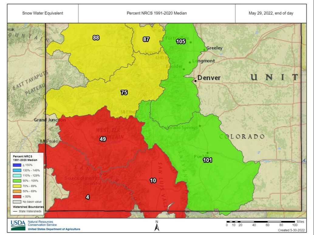 Snowpack
As the National Resources Conservation Service (NRCS) map shows, Arkansas Basin snowpack was at 101% of median as of May 29. The Fremont Pass SNOTEL site is reporting 90% of median. Reservoir Storage May 29 reservoir data from the U.S. Bureau of Reclamation showed 205,838 acre-feet of water stored in Pueblo Reservoir and 63.7% full. Twin Lakes Reservoir is 76.8% full at 108,219 acre-feet. Turquoise Lake is currently 58.1% full with 75,227 acre-feet in storage. U.S. Army Corps of Engineers data show 30,014 acre-feet of water currently stored in John Martin Reservoir. In spite of low water levels, the Colorado Parks and Wildlife website shows the east boat ramp at John Martin State Park is still open. River Flows Arkansas River flows are 202 cfs near Leadville, 690 cfs at Granite, 1,380 cfs at Wellsville and 1,570 cfs at Cañon City. Below Pueblo Dam and near Avondale, flows are 1,090 cfs and 1,390 cfs, respectively. The Rocky Ford gauge is reporting 495 cfs. Below John Martin Reservoir flows are 610 cfs, and at Lamar, 58.8 cfs. Voluntary Flow Management Program Flow management targets to support recreational boating are slated to begin July 1 after spring runoff. River Calls Currently, the Arkansas Basin has 14 calling water rights, including four on the mainstem – the Fort Lyon Canal (1887 priority), the Hyde Ditch (1887), the X-Y Irrigating Ditch (1889) and the Arkansas River Compact for flows at the Colorado-Kansas state line. The most senior calling right is the Model Ditch with an 1865 priority date on the Purgatoire River. The 1866 Gonzales Ditch right continues to call for Apishapa River water. Other tributary calls include the RB Willis Ditch on Wahatoya Creek, a Cucharas River tributary, the Reservoir and the Pedro Gomez ditches on the Huerfano River and the Tremayne Ditch No.1 on Fourmile Creek. The most junior calling water right on Ark River tributaries is the Waggoner Ditch on Stout Creek with an 1880 priority date. After desiccating winds, low precipitation and warm weather caused a precipitous drop in early May snowpack, Colorado welcomed a weekend storm that brought precipitation across the Arkansas River Basin, especially in the high country. 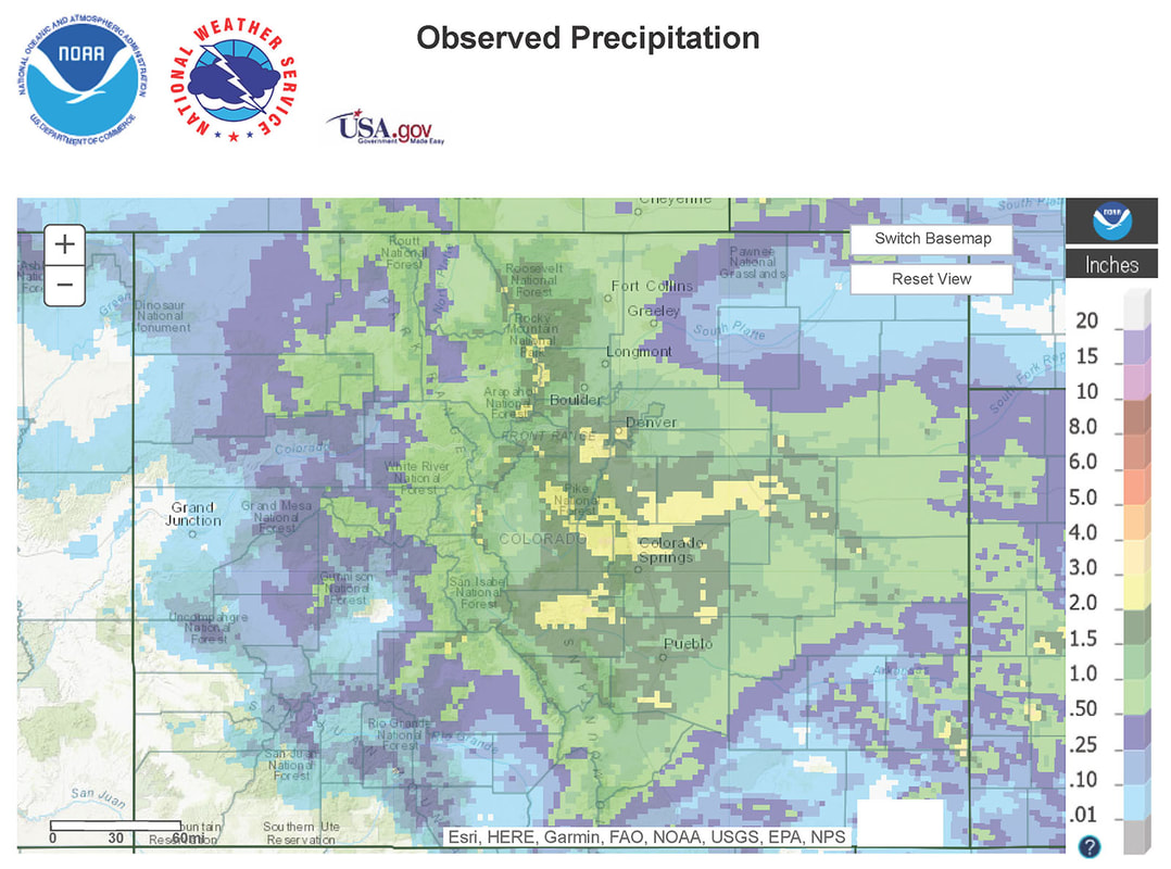 The Observed Precipitation Map from the National Weather Service shows recent precipitation totals in inches of water. The most recent U.S. Drought Monitor map, based on data from May 17, before the storm arrived, shows extreme drought across portions of Fremont, Las Animas and Kiowa counties and all of Bent County. The map shows all of Prowers and Baca counties under extreme to exceptional drought. The new NOAA three-month temperature and precipitation outlook shows a 70-80% probability for above-average temperatures and a 33-40% likelihood of below-average precipitation across the Arkansas Basin. Snowpack The National Weather Service reported the following three-day snowfall totals resulting from the recent storm system:
Arkansas Basin Snowpack Graph for May 23 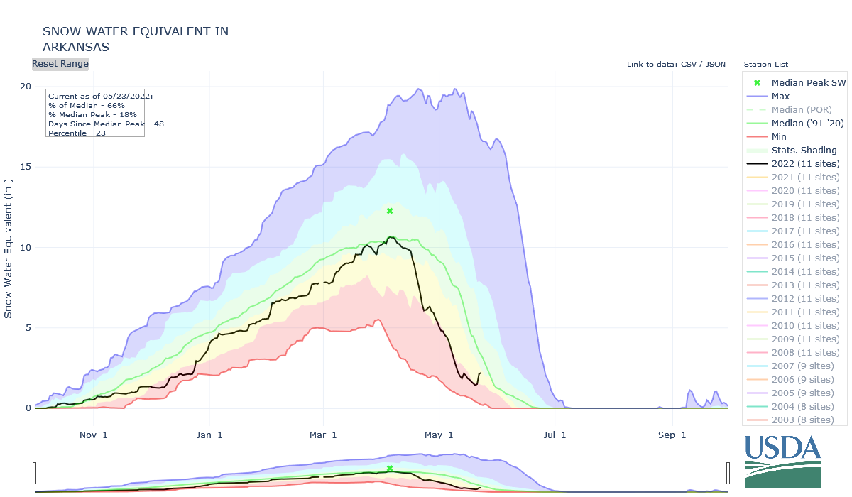 Reservoir Storage
Current reservoir data from the U.S. Bureau of Reclamation shows Pueblo Reservoir is 64.7% full as of May 22 with 209,009 acre-feet of water in storage. Twin Lakes Reservoir water storage increased to 105,150 acre-feet, 74.6% of full. With Turquoise Lake receiving Fryingpan-Arkansas Project imports, water storage has increased to 69,266.3 acre-feet or 53.5% of full, up from 44.8% a week ago. U.S. Army Corps of Engineers data show 29,625 acre-feet of water currently stored in John Martin Reservoir. The Southeastern Colorado Water Conservancy District board approved 32,848 acre-feet of Fry-Ark Project water allocations during its May 19 meeting in Pueblo. The District's forecast for total 2022 imports is 45,300 acre-feet. Southeastern District Senior Policy and Issues Manager Chris Woodka reported that approximately 16,000 acre-feet of Project water have been brought over from the West Slope as of May 23. River Flows Arkansas River flows, fed by spring runoff, continue to increase. Flows are 170 cfs near Leadville, 606 cfs below Granite and 892 cfs at the Wellsville gauge, which reported a peak flow of 1,620 cfs May 20. The Cañon City gauge currently reports 1,060 cfs, the same as last week; however, river flow at Cañon City reached 1,750 cfs May 21. Flows are currently 1,690 cfs below Pueblo Dam and 2,330 cfs near Avondale. Flows are 1,840 cfs near Rocky Ford and 598 cfs below John Martin Reservoir. The gauge at Lamar currently reports 53.5 cfs. River Calls Currently, the Arkansas Basin has 13 active calls. The three calls on the mainstem remain unchanged from a week ago – the 1887 Amity Canal water right, the 1889 X-Y Irrigating Ditch right and the 1949 Arkansas River Compact. The most senior calling right is the Titsworth Ditch with an 1861 priority date on Fourmile Creek. The 1866 Gonzales Ditch right continues to call for Apishapa River water, and the Hoehne Ditch, with an 1865 priority, has a call on the Purgatoire River. The Spanish Peaks Ditch (1873 priority) now has a call on the Cucharas River, and the Upper Huerfano No. 2 (1869 priority) has a call on the Huerfano River. New this week is a call on Wahatoya Creek, a tributary of the Cucharas River, by the R.B. Willis Ditch. Recent weather patterns have proven detrimental to the water outlook for the Arkansas River Basin with warm temperatures, minimal precipitation and high winds combining to reduce snowpack across Colorado, especially in the southern basins. Snowpack in the Rio Grande and San Juan/Dolores basins is alarmingly low at 2% and 7%, respectively. The most recent U.S. Drought Monitor map shows little change across Colorado with moderate to severe drought conditions in most of the Arkansas Basin. However, a new area of extreme drought has developed in the lower South Platte Basin. The new NOAA three-month temperature and precipitation outlook, updated monthly, should be available next week. Colorado Snowpack Map for May 15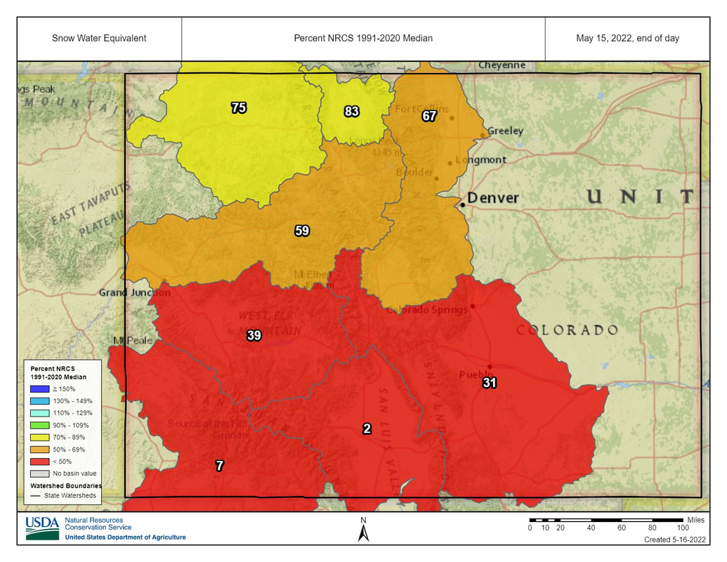 Snowpack
According to the National Resources Conservation Service (NRCS), Arkansas Basin snowpack, measured as snow-water equivalent, dropped to 31% of median as of May 15. The NRCS website indicates, "Analysis may not provide a valid measure of conditions" at almost all basin SNOTEL sites. An exception is the Fremont Pass site, which reports 73% of median snowpack as of May 16. Reservoir Storage Current reservoir data from the U.S. Bureau of Reclamation shows Pueblo Reservoir is 66.4% full as of May 15 with 214,378 acre-feet of water in storage. Twin Lakes Reservoir is is 68.4% full at 96,403.5 acre-feet. Turquoise Lake is currently 44.8% full and stores 57,995.4 acre-feet of water. U.S. Army Corps of Engineers data show 33,163 acre-feet of water currently stored in John Martin Reservoir, and Colorado Parks and Wildlife officials announced that John Martin Reservoir State Park's west boat ramp closed May 16 due to low water. River Flows Arkansas River flows have increased as early snowmelt runoff feeds upper basin tributaries. Flows are 260 cfs near Leadville, 382 cfs below Granite, 1,120 cfs at Wellsville and 1,060 cfs at Cañon City. Below Pueblo Dam and near Avondale, flows are 736 cfs and 1,180 cfs, respectively. Flows are 690 cfs near Rocky Ford and 567 cfs below John Martin Reservoir. At Lamar, flows are currently 51.4 cfs. Voluntary Flow Management Program Flow management targets to support the Arkansas River fishery ended May 15, and releases from upper basin reservoirs to support recreational boating are slated to begin July 1. River Calls Currently, the Arkansas Basin has 15 active calls. Three calls are on the mainstem – the 1887 Amity Canal water right, the 1889 X-Y Irrigating Ditch right and the 1949 Arkansas River Compact, which dictates flow at the Colorado-Kansas state line. The most senior calling right is the French Ditch Diversion with an 1861 priority date on French Creek upstream from Manitou Springs, and the 1866 Gonzales Ditch right continues to call for Apishapa River water. Other tributary calls are the Lake Miriam Ditch on the Cucharas River, the Chilcotte Ditch on Fountain Creek, the Canon Heights Ditch on Fourmile Creek, the DeWeese Dye Ditch on Grape Creek, the Hayden Supply Ditch on Greenhorn Creek, the Harrington Ditch on Hardscrabble Creek, the Sefton Ditch on the Huerfano River, the Spring Ditch on Middle Tallahassee Creek, the Hoehne Ditch on the Purgatoire River and the Waggoner Ditch on Stout Creek. Priority dates for these water rights range from 1864 to 1884. High winds continued to plague Colorado and the Arkansas River Basin this week, contributing to several wildfires. The U.S. Drought Monitor shows little change across Colorado with moderate to severe drought conditions across most of the basin, but the drought map has not been updated to reflect Sunday's snowstorm, which improved snowpack. The NOAA three-month temperature and precipitation outlook was recently updated, projecting above-normal temperatures and below-normal precipitation for all of Colorado through July. Colorado Snowpack Map for April 24 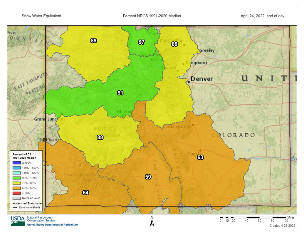 Snowpack
According to the National Resources Conservation Service (NRCS), basin snowpack dropped to 63% of median, measured as snow-water equivalent, as of April 24. Ark Basin SNOTEL data from April 25 show Porphyry Creek at 89% of median, Saint Elmo at 81%, Fremont Pass at 88% and Hayden Pass at 32%. The Apishapa SNOTEL station reads 150% of median, but that reading has been flagged as likely not valid. Reservoir Storage Current reservoir data from the U.S. Bureau of Reclamation shows Pueblo Reservoir is 68.8 % full with 222,249 acre-feet of water in storage. Twin Lakes Reservoir is 68% full with 95,873.7 acre-feet in storage. Turquoise Lake currently stores 47,501.5 acre-feet of water and is 36.7% full. U.S. Army Corps of Engineers data shows 44,444 acre-feet of water currently stored in John Martin Reservoir, well below its capacity of 348,599 acre-feet. River Flows Arkansas River flows have increased since last week, with gauges reading 318 cfs below Granite, 346 cfs at Wellsville and 352 cfs at Cañon City. Below Pueblo Dam, flows are 324 cfs, 745 cfs near Avondale and 162 cfs near Rocky Ford. Below John Martin Reservoir flows have ramped up to 75.4 cfs. At Lamar flows are currently 47.5 cfs. Voluntary Flow Management Program Flows at Wellsville are on target for the Voluntary Flow Management Program for April 1 to May 15. River Calls Calling water rights in the Arkansas Basin increased from 11 to 18 active calls this week. Seven calls are on the mainstem, including the 1875 Lamar Canal water right, the 1884 Fort Lyon Canal right and Las Animas Consolidated water right. The most senior calling water right is the Chilili Ditch with an 1862 priority date on the Huerfano River. Other tributary calls include Bray Ditch on North Cottonwood Creek with an 1867 priority date, the Bannister Sump Well on Fountain Creek with an 1866 priority date, the Titsworth Ditch on Fourmile Creek with an 1865 priority date, and the Gonzales Ditch on the Apishapa River with an 1866 right. |
